
News
Volcano In Japan Erupts And Rains Ash Down On Residents Up To 1.5 Miles Away
Japan has raised it emergency alert to a maximum level of five and pleaded residents to evacuate after a volcanic eruption.
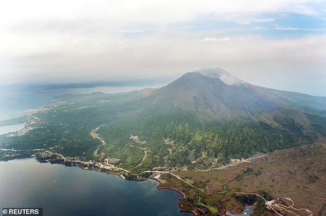
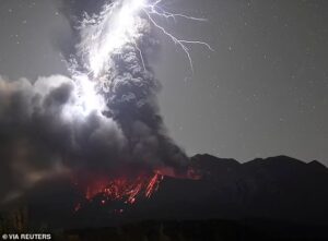
Sakurajima on western island Kyushu erupted at about 8.05pm local time today, the Japanese Meteorological Agency (JMA) said.
There were reports of volanic stones raining down at a distance of 2.5 km (1.5 miles) from the volcano, according to state broadcaster NHK.
The eruption alert level has been raised to 5, the highest, with some areas advised to evacuate, it added.
Nearby nuclear power plant Sendai saw no irregularities, regulators confirmed.
The facility is just 31 miles northwest of Sakurajima.
At 10pm local time (2.30pm GMT) a Japanese government spokesperson told reporters the government had not heard of any damage from the eruption.
There were no immediate reports of damage.
Sakurajima is one of Japan’s most active volcanoes and eruptions of varying levels take place on a regular basis. In 2019 it spewed ash 5.5 km (3.4 miles) high.
Video footage from Sunday’s eruption showed what appeared to be a red mass flowing down one side of the volcano, with red projectiles shooting out while smoke, hard to see in the darkness, billowed up.
Most of the city of Kagoshima is across the bay from the volcano but further residential areas within about 3 km (1.9 miles) of the crater may be ordered to evacuate, NHK said.
Officials at Prime Minister Fumio Kishida’s office were gathering information about the situation, it added.
In 2016 scientists led by Bristol University found that magma building up beneath Japan’s Aira Caldera, caused by the Sakurajima volcano, may threaten Kagoshima, known as the ‘Naples of the Eastern world’, with 600,000 inhabitants.
The team analysed surface deformation in and around the caldera and volcano to characterise the magma supply conditions, and how they can be used for eruption forecasting and hazard assessment.